Acadia to Haleakalea

Saturday, July 31, 2010

Alaska!

Seward, AK

Been in Alaska now for 6 days. Doesn't seem like that long, but the long days with little darkness, I think make the things run together. I didn't have internet to readily available in Denali, but my days were long anyway.

I flew in last Sunday night, we picked up the van from the port of Anchorage on Monday morning. Rain, rain, rain... it rained almost the whole way up to Denali. We stopped at a AK DOT control site to run, but it was a little too wet. Stopped in Wasilla for lunch, no Palin sighting nor any Russia sighting from Wasilla... but did see a Palin/McCain sweatshirt on a high school kid.

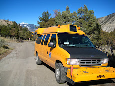
First day at Denali was filled with calibrations and verifications, but the second day we went for the glory. Most of Denali is roadless, peopleless, and bear-filled... however there is one road, one 93 mile road, of which about 80 miles are unpaved, mostly 1 to 1.5 lanes. We usually don't collect anything unpaved, but the park wanted video since most of the year its snow-covered, video will help them a lot with planning.

The park doesn't allow most private vehicles on the road, lots of buses though, lots... filled with people who would probably be too scared to drive the road anyway (read-too old). No guard rails, a couple of pot holes, some wolves, a couple of bridges, and one asshole NPS dude (that's you Brian D).

Did find out that one of my favorite bands, Trampled by Turtles - bluegrass from Duluth; was starting their Alaska tour in Denali. It was an awesome show... real nice treat.

Here's some shots of the road and from the road....
It wasn't this narrow for 80 miles, but really had to keep an eye out for buses on turns.
Tough to get the steepness, but this is right out the passenger window.

Really tough, per usual, to capture the scenery. The mountains in Denali though seem bigger, more rugged than anything down in America (it's what they the lower 48 up here). That along with the daylight, was twilight at 1am the other night... makes Alaska a pretty unique place.

Here's some more pictures from the road that day... saw a bunch of bears, a wolf that walked right past the van and some caribou.

So supposedly Mt McKinley is in the park... but it's pretty tough to get a clear day to see it. I wasn't lucky enough... Here's a couple of pics of mountains close to McKinley... think of it as about triple the size of anything you see.Pretty sure Denali (McKinley) is in the clouds on this pic... just imagine with me.

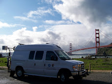
Since Denali, we've moved onto Seward. Kenai Fjords NP is located down here, and has some pretty neat glaciers. I'm heading out for a boat ride tomorrow... should have some more pictures.

Monday, May 24, 2010

Woodward, OK

Never heard of it? Yeah most people know one city in Oklahoma and that's only because it was named by someone who didn't want to be too original.

Finally back on the road again... Well I was actually on the road a bit in February, but it was a busy time and I was in San Francisco most of the time... so my evenings were filled with more entertaining things than blogging. Enter Woodward, OK... not exactly San Fran... in any way.

Stopped at the grocery store, saw a guy walk in with no shirt or shoes or socks for that matter, I'm guessing he had a mustache, but I'm not really positive. Made his purchase (pork rinds and cigs I'm guessing) and walked out. Proceeded to peel out in the parking lot in his '98 Lumina. It was sweet...

We flew into Tulsa today to pick up our truck and drive towards Capulin Volcano National Monument. Pretty short trip, it's actually just a continuation of our San Fran trip. That was part of our pilot project for this collection of Cycle 5 National Parks. We're using both our old truck and our new one for comparison and data compatibility.

Back to Woodward... actually had a decent dinner at a BBQ place, pretty authentic small town Oklahoma. Started pouring in the middle of dinner and hasn't really stopped for 2 hours, hopefully no hail on the truck tonight... Here's a little map of the drive, you can infer the correctly by the straight roads... not exactly driving through paradise.


View Larger Map

Friday, October 30, 2009

Canyonlands and Grand Junction

Well we finished Canyonlands, but not without some stress. It was about a 1.5 hour drive to the Southern section of the park this morning... everything was going well until we turned off the main road. Snow. Snow on the road. Can't really see all of the pavement when there's snow on the road and that means waiting... waiting for snow to melt... similar to watching grass grow. We kept driving though... I was thinking well shout, not gonna be home Sunday, Monday? Tuesday? Is it gonna get sunny to melt this?

Plus while this was happening the problem we had yesterday with the grade sensors was still not fixed. Things did not look good... The happiness of getting so many parks done so fast and ending cycle 4 on a high note... well it was falling away from me quickly.

Here's a map of the drive and a picture of the roads as we saw them...


View Larger Map


Well don't mean to keep you in suspense... but as we descended in elevation so did the amount of snow. By the time we got to our route, it was tough to find the fluffy stuff except on the surrounding mesas. I honestly couldn't believe it...

We pulled over to try a new strategy on the grade sensors. The snow fixed itself; we had to fix the grade sensors though... decided to take out a grade timer card in our main computer. Well our magic worked... not another grade sensor error the rest of the day.

The scenery around the Southern section wasn't quite as spectacular as the Northern, but we didn't get much of a chance to check things out. With this park being with a days drive of Denver, it's one I'd like to come back to at some time. Here's a pic of what they call "Wooden Shoe Arch." Pretty fitting I think...


So we finished the rest of Canyonlands by 1pm or so and got to Grand Junction around 430. Onto Colorado Monument tomorrow... and with that the end of Cycle 4! Denver Sunday... Hopefully in time for Vikings/Packers...

Thursday, October 29, 2009

Arches and Canyonlands

Yesterday we drove from Flagstaff to Moab and today we collected all of Arches and half of Canyonlands.

Here's a map of our drive yesterday....


View Larger Map

The drive yesterday was nice, snow/rain/sleet mix most of the time, slow drivers, and a lot of reading for me. We got to Arches about 230pm and were thinking about collecting but then it started to rain; so we bagged it. Drove around the park a good amount though; real neat place. I guess the park has about 2,000 arches, including the one on most of the Utah license plates (it's actually called Delicate Arch). We saw a lot of the Arches, but definitely not 2,000.

We were a little worried that the roads would still be wet or have snow on them today; but our luck has stuck with us and the roads were perfect. We not only finished Arches but we also got all of the Northern section of Canyonlands done. I estimated it would take us day to do each of these sections; so much for that. I gladly accept my error on that one.

Here's a map of our drive today....


View Larger Map

So tomorrow onto the Southern section of Canyonlands and then drive to Grand Junction, CO to finish up our last park of this cycle! Colorado National Monument. Should be done by Saturday afternoon...

Here's some pics from yesterday and today...

Balenced Rock... Really pretty crazy looking.... That boulder is huge, 55 feet high.
Delicate Arch - didn't have time and it was freezing out to make the 1.5 mile hike to the base of the arch; maybe next time.
Skyline arch
Double Arch

Canyonlands, the Colorado River is down there somewhere.

Wupatki, Sunset Crater, and Walnut Canyon

Next day we had 3 more smaller parks to do in Northern AZ. These had a little more mileage, but not many more routes. We finished all 3 of them by about 2pm. Felt pretty good to get 5 parks done in 2 days.

Wapatki and Walnut Canyon are similar to Montezuma and Tuzigoot as they were ancient ruins of peoples who used to live in the area around 1200 to 1300 A.D. We were able to tour one of the ruins a little bit, but for the most part we were focused on the finish line for this trip.

Sunset Crater is the youngest volcano of the Colorado Plateau. It erupted sometime between 1040 and 1100 and still has the lava flows to prove it.

Here's a map of our drive...


View Larger Map

I think I took some pics, but I was driving; so I don't think I got that many.

This is a pueblo at Wupatki...
These are some workers putting some silicon on the edge of the ledge. I guess it helps keep water out of the dwellings and further deteriorating them.

Montezuma Castle and Tuzigoot

So after a couple of weeks in the office and a trip back to MN for a wedding; I was back in the field on Monday October 26th, 2009. I had landed in Denver on Sunday night at about 10pm and I had a flight the next day at 8:19am. It sucked. I had to do laundry too. Got about 5 hours of sleep.

So I landed, we did a quick DMI calibration (measuring off 2640 ft with a wheel on a straight road then running the truck over and over it). Then we were up to Montezuma Castle and Tuzigoot (pronounced Too-zee-hoot; weird I know). They are basically both ancient pueblos of the Sinagua people, whom were native to the region around 1000 A.D.

These were both really small parks, got them both done in about 3 hours. Oh and this is our last trip in this cycle (yay!). 8 parks to go, but all of them can be done in a day or less pretty much.

Here's a map of our drive...


View Larger Map

And here's some pics of the ruins...

Montezuma's Castle (not revenge)...

Tuzigoot

Grand Canyon - South Rim

Ok so I've slacked again; uploading pictures is just so time-consuming. Or more likely I'm just lazy when I get back to my hotel room. But since we're now within 2 days of ending this cycle's collection (pretty sure I explained what a cycle was in a previous post); I figure I should at least catch up the last couple of weeks.

So I left you at the North Rim of the Grand Canyon. We finished that up the next day and drove down to the South Rim. Although the road we needed to finish was closed until about 1pm due to downed trees from the day before. So we had to bum around the lodge for a bit and get lunch in there. Which wasn't so bad either, just made for a long day. Here's a map of our drive...


View Larger Map

As a result of us finishing later on the North Rim, the four hour drive to the South Rim didn't start until 4pm. Which also meant I was gonna be late for the Vikings Packers game. I was fine with it since we got the North Rim done and I figured we'd get to our rooms and I'd catch the 2nd half. Little did I know that the Holiday Inn Express there does not carry ESPN! What kind of hotel doesn't have ESPN, I mean seriously.

Well we made it to a bar and I got in the 2nd half to see Favre finish off those Packers... just like he'll do again in Lambeau this weekend.

The next couple of days were busy busy busy.... We did get a break though since it rained the second day... just our luck; rain in the desert. We still managed to bust out about 120 routes in 2 days though. Our usual above average day was around 30 to 35 routes; we blew that out of the water. Helped that the routes were short and really close together, one trailer park had 26 loops in it!

Grand Canyon is a pretty neat place, the commercialization of it kinda sucks, but understandable since it's such an awesome sight. Tough to sum it up in words or pictures; however I do remember a quote I read while I was there, this guy didn't do so well at his attempt to describe it...

"The region is of course altogether valueless, ours has been the first, and will doubtless be the last, party of whites to visit this profitless locality."
- U.S. Army surveyor, Lieutenant Joseph Ives 1858

I mean he was there in 1857, before all the buildings, trails, and trains. It was probably a tough trip to get there, hot, sweaty, buffalo for dinner every night; but seriously that thing is an amazing wonder. I'm guessing he didn't go into the tourism industry. At least he's getting a call out in my blog 150 years later!

So we finished up the GRCA on a Friday and drove down to Phoenix; just in time for me to catch Game 2 of the Twins Yankees ALDS. That's all I'm gonna say about that game; I'm still bitter. Flew home to Denver the next morning... Here's a map of our drive.


View Larger Map

Here's some pics from the South Rim... Caught a rainbow on our second day there...

These pictures, per usual in National Parks, don't really do the scenery justice.